
↓
 

Knoxville Civil Engineering

...offering Civil Engineering services to the Knoxville Metro area

  • Home
  • Civil Engineering
  • Construction Management
  • Drone LiDAR Mapping
  • Environmental Engineering
  • Land Development Services
  • Structural Engineering
  • Transportation Engineering
  • Blog

Post navigation

← Older posts
Newer posts →

Why Soil Testing Supports Better Project Planning

Knoxville Civil Engineering Posted on June 20, 2026 by KnoxvilleCivilJune 19, 2026
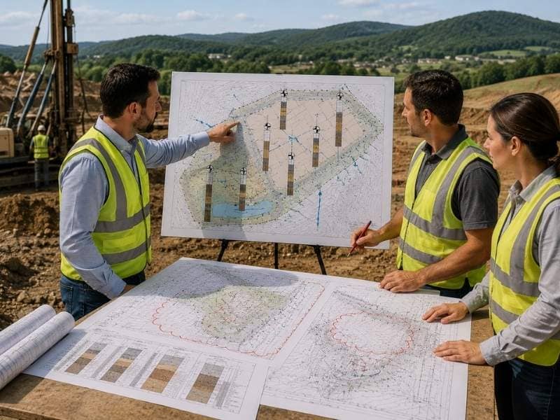
Civil engineers performing soil testing review on a development site with geotechnical plans, drilling equipment, and soil boring locations.

Soil testing gives a project team real information about the ground before any design work moves forward. In the Knoxville area, soil conditions can change quite a bit from one site to the next. Even properties that sit close together can behave differently underground. That kind of variation can affect everything from foundation design to drainage planning. Skipping soil testing means building a plan on assumptions instead of facts. Here is why this early step matters so much for the rest of a project.

Why Soil Testing Matters

Soil testing matters because every design decision that follows depends on knowing what’s actually in the ground. Engineers need to know how much weight the soil can support. They also need to know how deep bedrock sits and whether groundwater will affect construction. In the Knoxville area, this matters even more. Soil and rock conditions can shift a lot across short distances. A site that looks similar to one nearby on the surface can behave completely differently once construction begins. Soil testing replaces guesswork with real data. That data shapes decisions about foundations, grading, and drainage from the very start of a project.

How Soil Testing Finds Problems Early

Soil testing often reveals problems that don’t show up during a simple site visit. A few common findings include:

  • Weak or loose soil that can’t support a standard foundation.
  • Rock close to the surface that increases excavation costs.
  • High groundwater levels that complicate drainage and construction.
  • Old fill soil left behind from previous site work.

Finding these issues early gives the design team time to adjust the plan before construction starts. Discovering the same problems mid-project tends to cost far more. Crews and equipment are already on site, and schedules are already locked in. A soil test done early turns a potential surprise into a known factor the team can plan around.

Better Soil Data Means Better Plans

Engineers rely on soil testing results to make smart choices. They do not have to guess how the ground will behave. The data shows what type of foundation a site can support. It also shows whether retaining walls are needed. It shows how deep footings need to go to reach stable ground. With accurate soil information in hand, engineers can design a plan that fits the actual site conditions. That beats a generic plan that might not hold up. This kind of fit cuts down on design changes later. The plan already accounts for what the ground can and cannot handle.

How Soil Testing Can Help Save Money

Learning about ground conditions before construction starts helps a project. It avoids some of the most costly surprises in the building process. A foundation redesign after construction has already begun can mean tearing out completed work. It often means rescheduling crews who are already on site. Soil testing catches these issues on paper instead, where changes are far cheaper to make. Projects that invest in soil testing early tend to stay closer to their original budget. The design already reflects the real conditions underground rather than a best guess made before anyone broke ground.

Why Every Site Needs Its Own Soil Testing

Soil conditions can vary significantly even between two properties that sit close to each other. This is why borrowing data from a neighboring site rarely works. One property might sit on stable, well draining soil. The lot next door might have soft clay or a higher water table just a few feet down. Each site has its own geological history, and that history shapes what’s actually underground. A project might rely on soil testing from a different property. That risks planning around conditions that don’t match the real site. Every project benefits from its own soil testing. It’s the only way to know exactly what the ground at that specific location will do.

Soil testing turns an unknown into a known. That shift makes every later decision on a project easier to get right.

Frequently Asked Questions

What is soil testing?

Soil testing is the process of checking the ground before a project begins. It typically involves taking samples or borings at different points across a site. The results tell engineers what the soil and rock conditions look like below the surface.

Why is soil testing important?

Soil testing is important because it helps engineers understand the site before they design around it. Without accurate soil data, a design might not match what the ground can actually support. Good information up front leads to better plans and fewer surprises later in the project.

Can soil testing find problems underground?

Yes, soil testing can absolutely find problems underground that aren’t visible from the surface. It can reveal weak soil, rock close to the surface, high groundwater, or old fill material. Finding these conditions early gives the design team a chance to plan around them properly.

Why is soil testing important in the Knoxville area?

Soil testing matters a lot in the Knoxville area. Soil and rock conditions can change from one spot to another. A project built without local soil testing risks running into problems that local conditions could have predicted.

Can soil testing help save money?

Yes, soil testing can help save real money over the life of a project. Catching ground problems early means making changes on paper instead of during construction. Fixing a foundation issue after work has started almost always costs more. Planning around it from the start costs less.
Posted in civil engineering | Tagged soil testing

How Grading Plans Shape Successful Developments

Knoxville Civil Engineering Posted on June 19, 2026 by KnoxvilleCivilJune 19, 2026
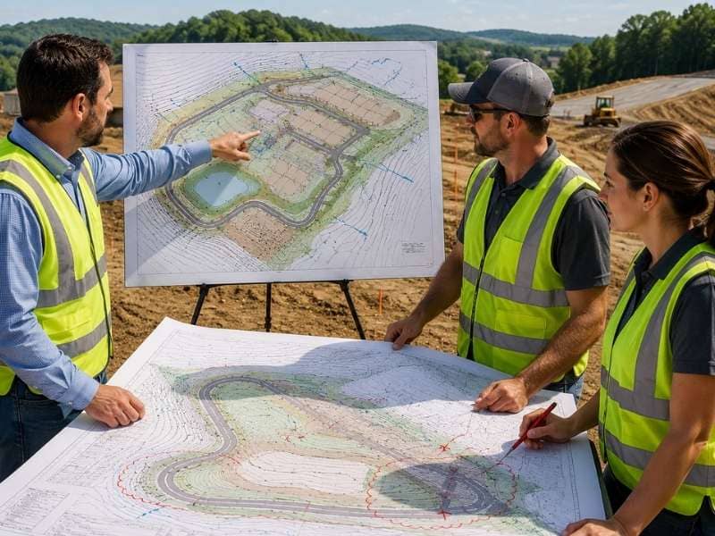
Civil engineers reviewing grading plans on a hilly construction site with contour lines, drainage features, and cut and fill areas.

A grading plans shapes the land before a single foundation gets poured. It often decides whether a project moves smoothly or runs into trouble. Hilly regions often need extra care with grading, so proper planning helps a project start on solid ground. Builders, engineers, and property owners all depend on a clear grading plan to know what the finished site will look like. Here is why this one document carries so much weight on a project.

Why a Grading Plan Matters

A grading plan acts as the blueprint for everything that touches the ground on a project. It tells the team where the high points sit and where the low points sit. It also shows how the land will transition between them once construction wraps up. On hilly sites, slopes are part of nearly every part of the property. This kind of planning matters even more than it does on flat ground. A grading plan worked out early gives every other part of the design a stable foundation to build around. That includes building placement and utility runs. Skipping this step tends to surface problems later, often after other decisions already depend on the land staying a certain shape.

How a Grading Plan Helps Manage Rainwater

A grading plan also controls where rainwater goes once it hits the ground. That control comes from how the land itself gets shaped. Sloping the ground away from buildings and paved areas sends water toward drains instead of letting it pool near a structure.

A few grading techniques make this work:

  • Sloping the soil gently away from foundations and walkways.
  • Building shallow swales that carry water toward a drainage point.
  • Setting high points and low points so water always has somewhere to go.

Without this kind of planning, puddles tend to form in low spots. Standing water can slowly damage pavement, siding, or landscaping over time. A grading plan that accounts for water movement from the start avoids most of these problems before they show up.

Why Slopes Need Careful Planning

Steep or uneven land creates real challenges that a grading plan has to address directly. A slope that’s too steep can erode over time, washing soil away and leaving bare or unstable ground behind. On sites with natural slopes, keeping grades within a safe range matters for both stability and long term durability. A grading plan sets out exactly how steep each section of the site can be. It balances what the land naturally wants to do with what the project actually needs. Getting this part right also reduces the amount of erosion control work needed later. A well planned slope tends to hold its shape instead of washing out after heavy rain.

How a Grading Plan Helps During Construction

During construction, a grading plan becomes the guide that crews actually follow on site. It shows how much soil needs to come out of one area. It also shows how much needs to go into another, often called cut and fill. Without that guide, crews are left guessing at elevations, and guessing tends to lead to redone work. A clear grading plan keeps everyone working from the same numbers. That cuts down on the kind of confusion that causes delays. Projects that follow a detailed grading plan from the start usually move through construction with fewer surprises and far less rework.

How Good Grading Helps Projects Last Longer

Good grading does more than just get a project through construction. It protects the site for years afterward. This matters most for roads, parking lots, and other paved surfaces that depend on stable ground. Pavement that sits on poorly graded soil tends to crack, settle, or shift sooner than it should. Those repairs add up fast. A grading plan that accounts for proper drainage and stable slopes gives pavement a much better chance of lasting. It tends to last as long as it was designed to last. Projects built on a solid grading plan tend to need fewer repairs over time. That keeps long term maintenance costs lower for whoever owns the property.

A grading plan pays for itself many times over, both during construction and for years after the project is finished.

Frequently Asked Questions

What is a grading plan?

A grading plan shows how the land will be shaped before and during construction. It maps out elevations, slopes, and drainage paths across the entire site. Builders and engineers rely on it to keep the project moving in the right direction.

Why is a grading plan important?

A grading plan is important because it helps control water, create safe slopes, and prepare the site properly for building. Without one, water tends to collect in the wrong places and slopes can become unstable. Getting this plan right early avoids costly fixes later in the project.

Why is grading especially important in hilly areas?

Grading is especially important in hilly areas because the land often has uneven slopes and changing elevation. Careful grading helps prevent erosion, drainage problems, and slope failures both during and after construction. A well prepared grading plan accounts for these challenges from the very beginning.

Who makes a grading plan?

Civil engineers usually create a grading plan for new projects. The work requires technical knowledge of slopes, drainage, and soil behavior. They study site conditions and design a plan that fits both the land and the project’s goals.

Can a grading plan help save money?

A grading plan can absolutely help save money over the life of a project. Good grading reduces the risk of water damage, erosion, and pavement failure down the road. Preventing these problems early almost always costs less than repairing them later.

Posted in civil engineering | Tagged grading plan

Flooding Happens Even If There’s No Flood Zone Designated

Knoxville Civil Engineering Posted on January 2, 2019 by KnoxvilleCivilFebruary 12, 2020

It may sound like a “DUH” statement, but flooding can happen even in areas that are not designated as a flood zone. A recent article from Louisiana prompted me to write this article. I always tell people that “the water can’t read the flood maps.” So, let me answer a few questions about flood zones so you’re not caught off guard.

 “…the flood wasn’t as near as bad as 2012, but neighbors say they are worried since the subdivision is technically not a designated flood zone .”

So, if you need help with an elevation certificate, give us a call today at  (865) 244-2877 . Our civil engineers are experienced in conducting flood elevation surveys and completing the elevation certificate. You’ll be glad you did when the rain starts.

Now, let’s review some information about flood zones and how they are determined to get a better grasp on this situation.

What are Flood Zones?

Flood Zones are lines drawn on a map that ESTIMATE the location (elevation) of potential flooding in a certain area. The key word in that sentence is Estimate. The location of a flood zone is actually a predicted elevation. Engineers conduct flood studies of potential flooding of a certain stream. These studies use estimates of the runoff potential of large areas. A certain drainage area may be 25 acres or 10,000 acres or more. We usually deal with areas of square miles, where each square mile is 640 acres.

“ALL FLOOD ZONES are NOT MARKED ON MAPS”

The flood zone shown on flood maps represent the elevations that the stream will rise to, if a certain storm event happens in the drainage basin. Engineers do their best, using the information they have, to estimate this elevation. But, again, the water doesn’t know how to read the map. And, we use a lot of estimating and historical data. Engineers can’t predict the future.

What are the Flood Zone Designations?

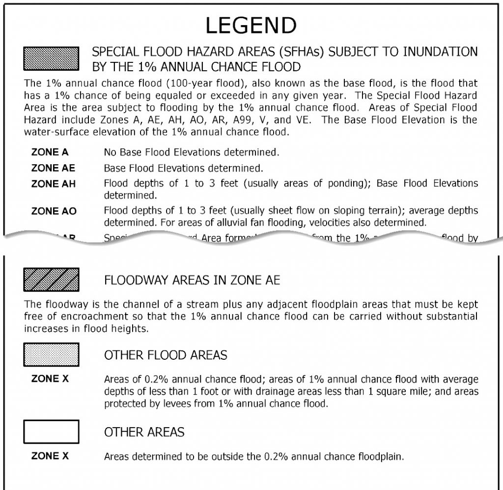
FEMA FLOOD MAP LEGEND

Zone AE and the other Zone A’s (AO, AH, A1-A30, A99, AR, AR/AE, AR/AO, AR/A1-A30, and Zone AR/A) are all indications of the 1-Percent Chance Storm (aka 100-year storm) event. This event will cause the nearby stream to rise to an elevation called the Base Flood Elevation (BFE). – This is the zone that you don’t want to be in. This is also called the Special Flood Hazard Area by FEMA. Being within any of these flood zone A’s requires you buy flood insurance.

Zone V and the other Zone V’s (VE, and Zones V1-V30) are the most hazardous of the Special Flood Hazard Areas. V zones generally include the first row of beachfront properties. The hazards in these areas increase because of wave velocity – hence the V designation. Flood insurance is mandatory in V zone areas.

Zone X (shaded) is also known as Zone B on older Flood Insurance Rate Maps (FIRMs). This zone represents the 0.2-Percent Chance Storm (aka 500-year storm) event. This flood zone does not need flood insurance purchased.

Zone X (unshaded) is also known as Zone C on older Flood Insurance Rate Maps (FIRMs). This zone represents land that is above or outside of the 0.2-Percent Chance (or 500-year) storm event. This flood zone designation also does not need flood insurance.

How Are Flood Zones Determined?

Storm water runoff is dependent on three things – the runoff coefficient, the rainfall intensity, and the area of the drainage basin. The area of a drainage basin can be measured fairly closely if we have accurate mapping. Most areas now have 2-foot contours or up to 10-foot contours to be able to draw out the area that feeds a certain stream.

BUT, the runoff coefficient and the rainfall intensity are only estimates.  The runoff coefficient is the rainfall that will not soak into the ground and runs off. We estimate the runoff coefficient using the vegetation, the amount of impervious surface (roofs & pavement) and the slope of the land.

The rainfall intensity for a certain storm event is estimated by scientific probabilities of a certain rainfall event returning again in a certain period. So, for instance, a 1-percent chance storm is that storm event that is predicted to have a 1-percent chance of reoccurring any time within a year. The 1-percent chance storm is also called the 100-year storm. This term is confusing since it incorrectly gives the idea that the storm won’t happen more often once in a hundred years. In fact a 1-percent storm can happen in any year, sometimes more than once. Compare that to the chances of a house fire happening, which is about a 6-percent chance in any given year.

The average property loss per burglary is a $2,251. For a fire, the average damage is $8,100. The average damage from 1-inch flooding of your home is around $5,100.

What if I’m NOT Shown in a Flood Zone?

elevation certificate - flood zone map, flood map

You may or may not be safe. If you’re shown as outside the Special Flood Hazard Area (Zones A or V) then you you don’t have to purchase flood insurance. But, remember what I said above, not all of the streams and ditches have been studied and the Base Flood Elevation determined.

I had a client once who asked for a flood elevation certificate so she could get flood insurance. Her house was 16-feet above the Base Flood Elevation. BUT, she had a ditch near the back of her house that overflowed and brought stormwater into her house causing significant damage.

The fact is that your Homeowners Insurance Policy DOES NOT cover damage from storm water or flooding. They don’t cover it because there is other insurance available for that from another carrier, FEMA. So, since FEMA takes the risk, there is no reason for the insurance companies to do so. They will assist in writing the flood insurance policy for you but the flood insurance is Underwritten by FEMA.

What if I AM Shown in a Flood Zone?

Get a flood elevation survey and elevation certificate completed. You may or may not be safe. Wait, that’s the same thing you said if I’m NOT shown in the flood zone. That’s right. The flood survey will determine the elevation of your home relative to the base flood elevation. This will allow you to get a flood insurance quote. This is required by FEMA if your home loan is connected to any federal money. And, most mortgage companies are, and would require flood insurance to protect themselves anyway.

This survey may also tell you that your home is actually NOT below the base flood elevation. What does that mean? If the ground elevation by your home is above the Base Flood Elevation then you may qualify for a Letter of Map Amendment (LOMA). The LOMA will remove you from the flood zone. This will end the need for you to buy flood insurance. But remember, the Base Flood Elevation can be exceeded also. So, depending on your situation, you may want to buy that policy anyway. You’ll get the lowest rate, and protect your home from the damages caused by an unexpected flood event.

Get a Flood Elevation Survey To Be Sure

flooding_flood_potential_sign

If you have questions the flood zone close to your home, call a local land surveyor or civil engineer. Get them to determine the elevation of your home and nearby grade. If the maps show you not in a flood zone, still ask questions about streams or drainage ditches near your home. When a rain event occurs, those streams and ditches will have water running in them. And, because they haven’t been studied doesn’t mean that the water won’t rise to a level that could flood your home.

The surveyor or engineer will measure the elevations of the ground surrounding your home. They will then compare that to the base flood elevation (1-percent chance) of the stream. They will produce a Flood Elevation Certificate that will document the survey. Your insurance company uses the information to quote a flood insurance policy.

So, protect your investment by calling a local surveyor or civil engineer. They are experienced in conducting flood elevation surveys and completing the elevation certificate. You’ll be glad you did when the rain starts. Call David today at (865) 244-2877.

Posted in civil engineering | Tagged elevation certificate, elevation survey, flood survey, flooding

Post navigation

← Older posts
Newer posts →
© Copyright CivilEngineeringKnoxville.com
2704 Cherokee Farm Way, Suite 101
Knoxville, TN 37920
Phone: (865) 244-2877

Privacy Policy
Web Development and SEO by N2Biz.co
Privacy Policy
↑