↓
 

Knoxville Civil Engineering

...offering Civil Engineering services to the Knoxville Metro area

  • Home
  • Civil Engineering
  • Construction Management
  • Drone LiDAR Mapping
  • Environmental Engineering
  • Land Development Services
  • Structural Engineering
  • Transportation Engineering
  • Blog

Post navigation

← Older posts
Newer posts →

Flood Study Requests Extend Beyond Flood Zones

Knoxville Civil Engineering Posted on June 25, 2026 by KnoxvilleCivilJune 24, 2026
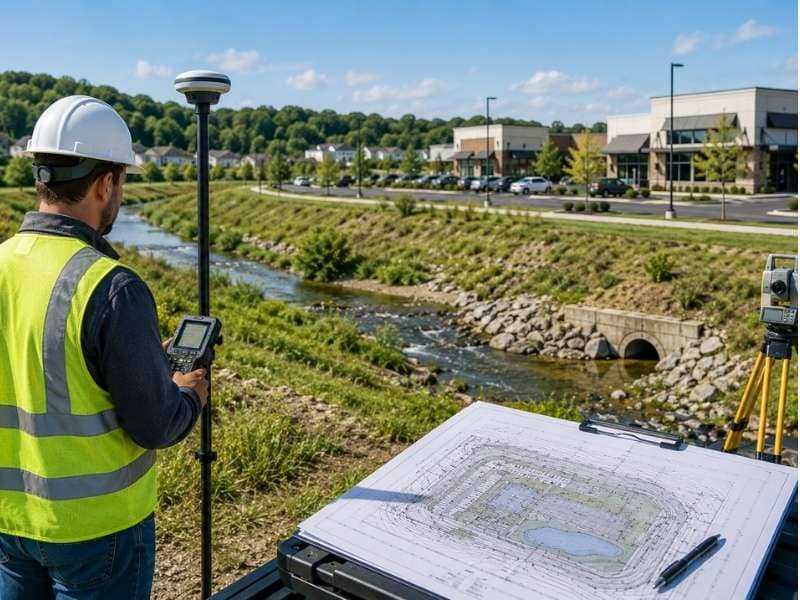
Flood study evaluation near a commercial development site with a creek, drainage channel, and survey equipment outside a mapped flood zone

A flood study looks at how water moves across and around a site. For years, project teams ordered one mainly when a property sat in a mapped flood zone. That habit is changing. More agencies and engineers now ask for a flood study even when the site sits well outside those zones. The reason is simple. A map line doesn’t always match what the water actually does. Knowing the difference early can keep a project on schedule and out of trouble.

Why More Projects Need a Flood Study Today

Flood maps don’t tell the whole story. Many date back years and haven’t kept up with new roads, rooftops and parking lots. All that hard surface sends more water downhill, faster than the old maps assumed. A site that looked dry on paper can still take on water in a heavy storm.

Agencies have noticed. After years of costly flooding, many now ask for proof that a project won’t push water onto its neighbors. A flood study gives them that proof. It shows how water reaches the site, where it goes and how the design handles it.

This is why a mapped flood zone is no longer the only trigger. A site near a creek, at the bottom of a slope or downstream of new development may all draw the same request. The map is just one clue among several.

How Nearby Water Features Can Lead to a Flood Study

Water doesn’t care about property lines. A feature next door can put a site at risk, and a reviewer will want to know how. That is often what turns a routine project into one that needs a flood study.

A few site features raise the question fast:

  • A creek or stream along or near the property.
  • A ditch or channel that carries runoff during storms.
  • A pond or wetland that rises after heavy rain.
  • A low spot where water collects and lingers.

Each of these can send water toward a building or hold it on the site. An engineer studies how high the water can get and how often. That answer shapes where it is safe to build and how high the ground needs to sit. Without the study, the team is guessing.

Why Starting a Flood Study Early Can Save Time

A flood study works best near the start of a project, not the end. Its results can move buildings, raise pads and reshape the whole site plan. Find that out early, and the design grows around it. Find it out late, and the team has to tear the design apart and rebuild it.

Timing also affects approvals. Many agencies want the flood study in hand before they review the larger plan. A team that waits until the end can stall there, watching the schedule slip while the study runs.

Starting early costs a little upfront effort. It saves far more later. The study points out the real limits of the site before anyone commits to a layout that won’t work.

How a Flood Study Can Change Project Plans

The findings from a flood study can reshape a project in real ways. The biggest change is often where buildings can go. If part of the site can flood, the design moves structures to higher, safer ground.

Grading usually changes too. A study might call for raising a building pad above the expected flood level. It can also redirect how water flows across the site so it stays away from doors and foundations. These moves protect the people and property that will use the site later.

Drainage plans feel the effect as well. A study can show that the site needs more room to hold water, or a clearer path to send it away. None of these changes are busywork. Each one lowers the odds of flooded buildings down the road.

Why Good Site Data Is Important for a Flood Study

A flood study is only as good as the data behind it. Engineers need a close, accurate picture of the land and the water near it. Rough or old information leads to a study that misses the real risk.

The most useful data comes from a detailed survey. Engineers want tight ground elevations across the site and the area around it. They also want cross-sections of any nearby channel, which show how much water it can carry before it spills over. Together, these reveal how high a flood could climb.

The size of the upstream area matters too. The more land that drains toward a site, the more water can arrive at once. Solid data on all of this leads to a study a reviewer can trust, and a design built on facts instead of guesses.

Frequently Asked Questions

Why do some projects need a flood study?

A flood study shows how water could reach and affect a site during a storm. Agencies and engineers use it to make sure a project stays safe and doesn’t worsen flooding nearby. Projects near water or in changing areas are the most likely to need one.

Can a project need a flood study if it is outside a flood zone?

Yes. Flood maps can be old and may not reflect new development or current drainage. A site outside a mapped zone can still flood, so an agency may request a study to check the real risk.

What site features can trigger a flood study?

Streams, ditches, ponds, wetlands and low areas all raise the chance of one. Each can move water toward a site or hold it there after heavy rain. A reviewer will often ask for a study to see how that water behaves.

When should a flood study be done?

Early in the project is best. Doing it up front lets the results guide where buildings go and how the team grades the site. Waiting until the end can force major redesigns and hold up approval.

How can a flood study affect project design?

Its findings can shift building locations, raise pads and change drainage plans. The goal is to keep structures above the expected flood level and steer water away from them. These changes lower the risk of flooding for the finished site.
Posted in environmental engineering

Drainage Design Reviews Are Delaying More Projects

Knoxville Civil Engineering Posted on June 24, 2026 by KnoxvilleCivilJune 24, 2026
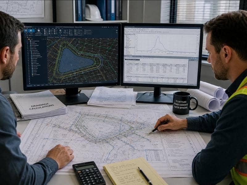
Civil engineers reviewing drainage design plans and stormwater calculations to help reduce review delays and improve approvals.

Drainage design used to clear reviews without much fuss. Those days are fading. Reviewers now check these plans far more closely, and that extra attention adds weeks to many project schedules. A plan that looks finished can still come back with a page of comments. Each round of comments means more time before a shovel hits the ground. Most of these delays trace back to a few clear causes. Fix those, and a drainage plan moves through review much faster.

Why More Drainage Design Plans Are Facing Longer Reviews

Reviewers are paying closer attention than they used to. Bigger storms and more flooding have put drainage under a microscope. When a system fails, the damage hits roads, homes and budgets, so towns want to catch weak spots on paper first.

Stricter standards add to the load. A plan now has to prove it can handle larger storms and cleaner runoff. Each new rule gives a reviewer one more thing to verify before signing off.

Staffing plays a part too. Many review offices handle more projects than they have people for. A solid plan still waits in a queue, and a flawed one waits even longer. None of this points to a broken system. It just means a drainage plan faces a tougher, slower path than it did a few years ago.

How Small Mistakes Can Delay Drainage Design Approval

A drainage plan can stall over details that seem minor. A reviewer can’t approve what they can’t follow, so a missing number or a mismatched sheet sends the whole package back.

The most common slip-ups show up again and again:

  • Missing or unclear storm calculations that back up the design.
  • Labels and plan sheets that don’t match the report.
  • Pipe sizes or slopes left off the drawings.
  • Old site data that no longer matches the current plan.

Each of these forces a fix and a fresh review. One small error can cost a week or more. Catching them on an internal check, before the plan ever reaches the agency, is the cheapest time to fix them. Clean plans clear faster.

Why Good Site Information Matters in Drainage Design

Drainage design only works when the site data behind it is right. Engineers build these plans on top of survey, topography and soil information. If that base is off, the whole design is off with it.

Topography is the big one. Water follows the slope of the land, so a drainage plan lives or dies on accurate ground elevations. Bad or outdated topo can send a model in the wrong direction and produce numbers a reviewer won’t trust.

Soil data matters just as much. How fast water soaks into the ground shapes the size of ponds and pipes. Guess wrong, and the design either floods or wastes space. Good site information up front leads to a plan that holds up under review the first time.

How Project Changes Can Affect Drainage Design

Drainage design doesn’t sit still while the rest of a project changes. Move a road, raise a pad or add a building, and the way water flows across the site changes with it. The drainage plan has to change to match.

These ripples catch teams off guard. A small tweak to the grading can shift where water collects. More pavement or roof area means more runoff for the system to handle. Each change can push the plan back into review, even when the rest of the design looks ready.

That is why late changes hurt the most. A change after approval can undo work the reviewer already signed off on. Locking down the layout early keeps the drainage plan from bouncing through review more than once.

Why Teamwork Helps Drainage Design Projects Stay on Track

Drainage delays shrink when the whole team talks early and often. The engineer, the builder, the owner and the reviewer all touch the plan in some way. When they share information freely, problems surface while they are still cheap to fix.

A quick call can settle a question that a formal comment letter would drag out for weeks. When a builder flags a field issue early, the engineer can adjust the plan before it becomes a costly change. When an engineer asks a reviewer about a local rule up front, the first submittal lands much closer to approval.

Good communication won’t erase every delay. It does cut out the avoidable ones. A team that works together moves a drainage plan from draft to approval with far less back-and-forth.

Frequently Asked Questions

Why are drainage design reviews taking longer?

Reviewers now check drainage plans more closely because failed systems cause real flooding and damage. Stricter storm and water-quality standards give them more to verify, and busy offices add wait time. Together, those factors stretch out the review.

What mistakes can slow down a drainage design project?

Missing calculations, mismatched sheets and incomplete reports are common culprits. Each one stops a reviewer from approving the plan, so the package goes back for a fix. Outdated site data causes the same problem when it no longer matches the design.

Why is site information important for drainage design?

Accurate survey, topography and soil data form the base of every drainage plan. When that data is wrong, the design points water the wrong way or sizes ponds and pipes poorly. Reliable information up front helps the plan pass review on the first try.

Can changes to a project affect drainage design?

Yes. Shifts in grading, roads or building footprints change how water moves across a site. Someone has to update the drainage plan to match, and that update often means another round of review.

How can teams help avoid drainage design delays?

Open communication between the engineer, builder, owner and reviewer catches problems early. A quick conversation can resolve an issue that a formal comment would stretch out for weeks. Early coordination keeps the plan from cycling through review more than once.

Posted in civil engineering | Tagged Drainage design

When Roadway Design Creates Long-Term Value

Knoxville Civil Engineering Posted on June 22, 2026 by KnoxvilleCivilJune 19, 2026
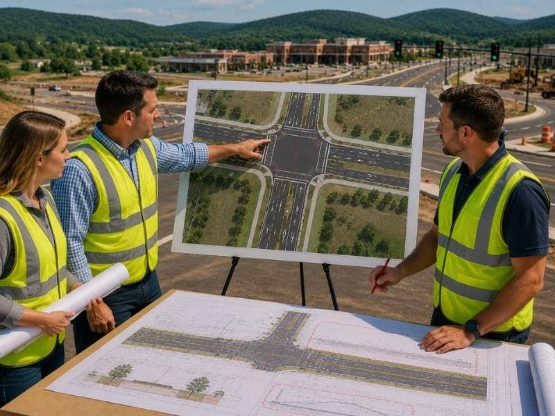
Civil engineers in safety vests reviewing a roadway design with turn lanes, intersections, and future road improvements at a growing development site.

Roadway design shapes how an entire community moves, not just how a single street looks on paper. New development in many regions is creating a greater need for better roads. Those roads need to handle the traffic that new projects bring. Good roadway design accounts for this from the start. It does not just react to problems after they show up. Here is why this part of planning creates value that lasts long after construction wraps up.

Why Roadway Design Matters

Roadway design matters because growing communities depend on roads that can keep up with new development. As homes, stores, and offices get built, the roads connecting them need to handle more cars and trucks than before. A region with real growth often finds its older roads were never built for this kind of demand. Good roadway design looks at where development is heading, not just where it stands today. That forward looking approach gives a community roads that support growth instead of roads that constantly fight against it.

How Better Roads Help Traffic Move

Roadway design directly shapes how smoothly traffic moves through an area. Lane widths, turn lanes, and intersection layouts all affect how easily cars and trucks get where they’re going. A road with proper turn lanes keeps cars from backing up behind a driver waiting to turn left. Smooth signal timing keeps traffic moving instead of stacking up at every light. Even small design choices can matter a lot, like where a merge lane begins. Daily travel feels easier when these details get worked out at the design stage. Fixing them after drivers start complaining costs far more.

Why Roads Should Be Built for the Future

Roads should be planned with more than current traffic in mind. Growth tends to follow new development, often faster than people expect. A road designed only for today’s traffic count often becomes outdated within just a few years. Reserving extra right-of-way width during design lets a road add lanes later. This avoids tearing up land that’s already been built on. Choosing intersection layouts that can support a future turn lane avoids a full rebuild down the road. Specifying pavement built for higher future traffic loads keeps the road from wearing out too soon. These choices cost very little extra at the design stage. They save a community from expensive retrofits once the growth actually arrives.

How Good Roads Help Local Communities

Better roads do more than move cars. They shape how easily people reach the places they need to go. A well designed road network gets kids to school safely. It gets shoppers to local stores and workers to their jobs without unnecessary detours. Roadway design that considers walking paths, school zones, and access points supports the everyday rhythm of a community. It is not just about traffic counts. Communities with thoughtful roadway design tend to see new development follow more naturally. Accessible roads make nearby land more attractive to build on.

How Smart Roadway Design Saves Money

Smart roadway design saves money by getting the engineering right the first time. Pavement built to the correct thickness lasts far longer. A road designed for less traffic than it actually carries wears out fast. Intersections designed with enough capacity from the start avoid a costly teardown a few years later. A road that gets these specifications right the first time avoids expensive rework. That kind of rework usually comes from underbuilding now and fixing it later. This upfront accuracy is where roadway design creates real, long-term value for a community.

Good roadway design pays off well beyond the day construction finishes. It shapes how a community moves and grows for years to come.

Frequently Asked Questions

What is roadway design? 

Roadway design is the process of planning and designing roads for safe and smooth travel. It covers everything from lane widths and intersections to signal timing and future capacity. Engineers use roadway design to make sure roads work well both now and later.

Why is roadway design important? 

Roadway design is important because it helps people travel safely while supporting communities as they grow. Poorly designed roads create bottlenecks, safety risks, and frustration for everyday drivers. Good design solves these problems before a road ever opens to traffic.

Why should roads be planned for future growth?

Roads should be planned for future growth. More people and new development almost always bring more traffic over time. A road designed only for today’s needs often becomes outdated within just a few years.

How does roadway design help communities? 

Roadway design helps communities by making it easier to reach homes, schools, stores, and businesses. Well planned roads reduce travel time and make daily trips less stressful. They also support safer access for pedestrians and cyclists near schools and neighborhoods.

Can good roadway design save money?

Yes, good roadway design can absolutely save money over time. Careful planning reduces the need for costly repairs and major redesigns later. Getting the engineering right from the start almost always costs less than fixing it after the road is built.

Posted in transportation engineering | Tagged roadway design

Post navigation

← Older posts
Newer posts →
© Copyright CivilEngineeringKnoxville.com
2704 Cherokee Farm Way, Suite 101
Knoxville, TN 37920
Phone: (865) 244-2877

Privacy Policy
Web Development and SEO by N2Biz.co
Privacy Policy
↑